Site Map
New Madrid Fault

yellow=this week, orange=24hrs, red=1 hr; smallest are 2.5 to 4 mag.
UTC -5 = CDT Click for more.
Lookup A Recent Quake
- Google maps, world, past hour/day/week - USGS
- New Madrid Fault earthquake seismic activity - CERI
- Today-yesterday preliminary reports - USGS
- US quakes above mag 1 very recent thru past week
- Last 24 hours world (blue stars) - USGS
- Year quakes NM+Arkansas - Google map overlay Ark Geol Survey
- Central US Archives - USGS
- This week's world quakes - UK
 Recent earthquake news - Google
- New Madrid Fault news - Google
- Current quake news pictures - Yahoo
- Areas of world, earthquakes in last 14 days - SLU
- Clickable map of recent midwest activity - CERI
- Here's the last week's worth of shakes at New Madrid.
- Calif recent, map
- IRIS world map
- All world seismic activity today greater than 4.5 magnitude - SLU
- World earthquakes, last few days - USGS
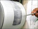
Want to see a needle shake view of a recent quake?
http://folkworm.ceri.memphis.edu/heli/ go here...
www.usarray.org - a program to bury many seismic reporting stations in remote locations for a few years at each place, to better understand the US deep geological makeup. The stations report via cellphone and keep time via GPS satellites. The program started in the west and is just coming to the Midwest. They can't afford to leave the units in place, forever. .
http://rev.seis.sc.edu/stations/NM/PBMO - (Rapid Earthquake Viewer) a newer display of a seismograph needle shake. This station is at Three Rivers college campus, Poplar Bluff, Mo, at north edge of the bootheel. Other stations in this system are at Portageville, Carbondale, and in West Tenn. http://rev.seis.sc.edu - main page.
The Global Earthquake Explorer - downloadable software. Not really worth it just yet.
You can sign up for the ANSS Earthquake Notification List (ENS) http://earthquake.usgs.gov/eqcenter/ens/ You can select your region of interest and your own magnitude threshold (separate night and day configurable).
Technical quake data lookup
- Bill Emerson Bridge - has 80+ reporting sensors on and around the bridge at Cape Girardeau.
- Nat'l Strong Motion Program - US Geol. Survey
- iris.edu/data

The Mississippi River Bridge between Caruthersville MO and Dyersburg TN, built about 1970, needs millions of dollars more for a seismic retrofit.Explorers Marquette and Joliet paddled down the Mississippi River in 1673. The landform changed as they passed New Madrid territory. The great swamp of Southeast Missouri was not drained until the early 20th century. Their log:
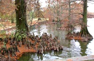
Cypress trees and "knees" at Reelfoot lake. Scientists aren't sure of the benefits of the knees.
Here we began to see canes, or large reeds, which grow on the bank of the river; their color is a very pleasing green; all the nodes are marked by a crown of long, narrow, and pointed leaves.The first written account of an earthquake in the region was by a French missionary on a voyage down the Mississippi River. He reported feeling a distinct tremor on Christmas Day 1699 while camped near what is now Memphis, Tennessee. sourceThey are very high, and grow so thickly that The wild cattle have some difficulty in forcing their way through them. Hitherto, we had not suffered any inconvenience from mosquitoes; but we were entering into their home, as it were. This is what the savages of this quarter do to protect themselves against them. They erect a scaffolding, the floor of which consists only of poles, so that it is open to the air in order that the smoke of the fire made underneath may pass through, and drive away those little creatures, which cannot endure it; the savages lie down upon the poles, over which bark is spread to keep off rain.
Bible Lands
The Sea of Galilee, in far northern Israel, drains through the deep (earthquake rift) Jordan River valley to the Dead Sea. This same rift separates Saudi Arabia from Egypt - see lower map. The entire region is rife with rifts. Some say a rift goes directly across the Golgotha hill where Christ was crucified.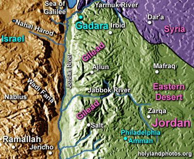
Destruction of Sodom and Gomorrah, 1900 BC - near Dead Sea - Gen. 19 Valley in above map drains into the Dead Sea.
Fall of Jerico 1400 BC - double quake?. Quakes have dammed the Jordan River repeatedly, sometimes for several days. See Jerico at bottom of above map. Moses, in Exodus 14-15; Joshua, in Joshua 3:14-17; Elijah in 2 Kings 2:7-8; and Elisha in 2 Kings 2:13-14 actually called upon God to part the waters. Each time, God responded by physically separating the water with, at least in the first three stories, dry land under foot. ref
"...Jesus cried again with a loud voice and yielded up his spirit. And behold, the curtain of the temple was torn in two, from top to bottom; and the earth shook, and the rocks were split; the tombs also were opened, and many bodies of the saints who had fallen asleep were raised, and coming out of the tombs after his resurrection they went into the holy city and appeared to many. When the centurion and those who were with him, keeping watch over Jesus, saw the earthquake and what took place, they were filled with awe, and said, 'Truly this was the Son of God!'" (Matt. 27:50-54)
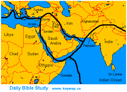
Heavy black lines on map show tectonic plate boundaries. A second great earthquake occurred on Easter morning according to Matt. 28:2 at the time of the resurrection. Evidently these two earthquakes have not yet been noted in any archaeological site damage thus far excavated. Another "providential" earthquake recorded in the Bible was the Lord's means of releasing Paul and Silas from jail in Philippi. The terrified jailer and his family fled for refuge not out of the city, but into the kingdom of God through faith in the Lord Jesus Christ, (Acts 16:11-40). Philippi is in central north Greece, near the edge of a tectonic plate. The giving of the Law to Moses on Mount Sinai was accompanied by a frightening earthquake (Exodus 19:16-18). from http://www.ldolphin.org/quakes.html
Power of God
Fundamentalist Christian groups link to this site, to warn we need to be prepared to meet our Maker. That's all well and good and needed. But we would point out a God who can release seismic energy when He chooses, even contingent on what we mortals are doing, has the same ability to release that much power in our personal lives. It takes lots of focus to learn HOW He wants to do that in our own lives. Charles F. Richter, former President of the Seismological Society of America and the originator of the "Richter scale," in the December 1969 issue of Natural History magazine said: "One notices with some amusement that certain religious groups have picked this rather unfortunate time to insist that the number of earthquakes is increasing. In part they are misled by the increasing number of small earthquakes that are being catalogued and listed by newer, more sensitive stations throughout the world" (page 44).
Powered by Show-Me.net