Origins of New Madrid Fault
Mafic intrusions of plutons
The continents played tug-of-war a few hundred million years ago. (45 maps) South America came pushing on New Orleans. Africa pushed and pulled on the Carolinas. (See further down this page.) As many as 20 glaciers [Illinois State Museum] came and went. North America tried to break in two, twice, at New Madrid. Neat animation
Pluton - Something like a volcano
The pulling and pushing allowed hot magma from the earth's inner core to rise through deep cracks and collect as plutons nearer the surface (see illustrations below). The dense plutons tend to pull down the land around them, form rifts and faults and further destabilize the seismic area. Quakes frequently happen near plutons. They are named for Pluto, the Roman god of the underworld.
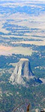
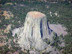
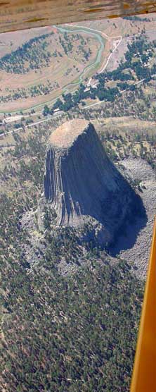
Pictured below is a landmark pluton, Devil's Tower in Wyoming, 200 miles east of Yellowstone National Park, exposed by erosion. See maps down this page for plutons in Southeast Missouri.
 |
 |
|
Earthquakes are nature's way of relieving tension. The continents are still changing.
When the Missouri dinosaur became trapped in a fault west of Cape Girardeau, the Great Plains was still a great lake.
Geology of central US - relating to quakes
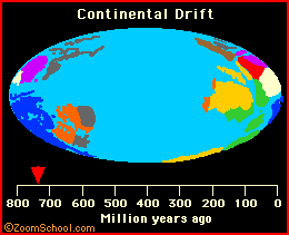
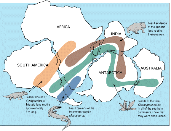
Sir Francis Bacon noticed on maps of 300 years ago that the continents seemed to fit together. Species also fit. Click illustration for more.
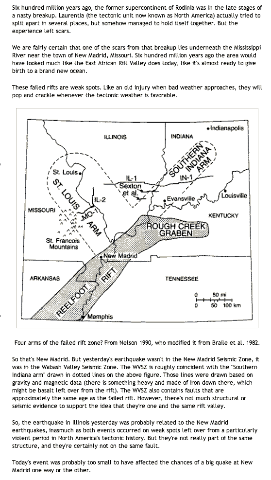
600 Million - Mississippi Embayment
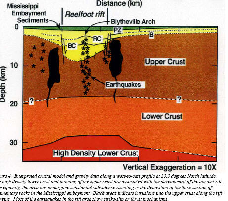
More than 600 million years ago, in the Proterozoic Era, the area now known as the Mississippi Embayment was pushed upward by molten rock from the underlying mantle. Faults formed, and over many millions of years, a rift structure now known as the Reelfoot Rift developed.
Dense mantle material was injected into the lower crust, creating a pillow-shaped structure which was heavier than the surrounding rocks. As the upwelling ceased, the entire rift subsided, and filled with sediments eroded from its flanks. Memphis Aquifier, Reelfoot Rift
200 Million Years ago
Then seas covered the area, laying down thick sequences of sediments which eventually hardened into limestones, sandstones and shales. During the Mesozoic Era, about 200 million years ago, rifting took place along the east coast of North America as the Atlantic Ocean began to open, resulting in the continent being stretched or extended, and in the Reelfoot Rift being pulled apart in a new episode of rifting.
Plutons (deep reservoirs of magma) formed along the flanks and axis of the rift, as molten rock moved upward along the ancient faults and then cooled before reaching the surface. Once again the rifting ceased and again, the ocean advanced over the area and receded; this time the sands, clays and gravels it deposited were not buried deeply enough, or long enough to become rock. At Memphis, this prism of unconsolidated material is approximately 3200 feet thick and covers the terrain from Little Rock, AR to the Tennessee River.
 |
It is the reactivation of these ancient buried faults under the stress of continuous intracontinental pressure from the east and west (called a compressive stress regime) that is responsible for the earthquakes occurring in the NMSZ at present. The continuous pressure results in strain energy accumulating in the buried faults, a very small portion of which is released in the numerous low-magnitude earthquakes recorded in the NMSZ each year
by Ann G. Metzger and Jill Stevens Johnston
Center for Earthquake Research and Information
University of Memphis
rockhoundingar.com/geology/fault.html
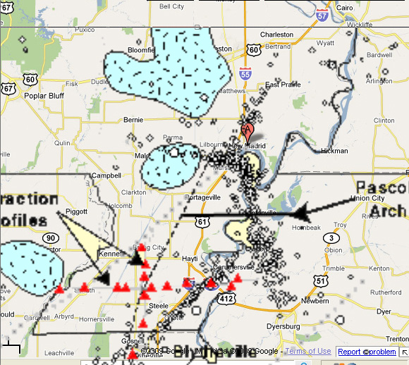
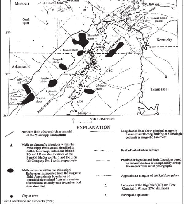
Plutons are roughly superimposed on a roadmap. Ignore the red triangles.
The Bloomfield pluton covers between Sikeston and Bloomfield. Civil war troop
movement
through that area was hampered by a swamp with waist-deep water (land weighted
down).
---
In geology, mafic minerals and rocks are silicate minerals, magmas, and volcanic and intrusive igneous rocks that have relatively high concentrations of the heavier elements. The term is a combination of "magnesium" and ferrum, the Latin word for iron [ma(gnesium) + f(errum) + ic]. In spite of the name, mafic magmas also are rich in calcium and sodium.
en.wikipedia.org/wiki/Mafic
The Mississippi Embayment formed from the filling in of a
shallow saltwater basin that existed as a bay jutting northward from the Gulf of
Mexico into the North American continent as far as Illinois during the
Cretaceous period (165 million years ago to 65.5 million years ago). The
Mississippi Embayment sedimentary rocks are rich with now extinct clams, snails,
sharks, and marine reptiles such as mosasurs and plesiosaurs that thrived during
the Cretaceous.
Between two and twenty miles below the surface of the Mississippi Embayment lies
the rift of the earth�s crust called the Reelfoot Rift. A rift is a split in the
crust. Some rifts such as the Great Rift Valley extending from Mozambique to
Syria in East Africa and the Middle East are exposed rifts. The Reelfoot Rift is
a buried rift. Because it is buried, it was only recently discovered.
Rifting of tectonic plates may result in the formation of �triple junctions� and
�aulacogens�. A triple junction is the point at which three intersecting
lithospheric plates are separated by �arms�. The arm along which the motion that
spreads the plates apart ceases (no longer works) is termed the �failed arm�,
�failed rift�, or �aulacogen�. Spreading or rifting along the other two arms of
the triple junction can form new oceanic basins, such as the Proto-Atlantic
Ocean and the Atlantic Ocean. The Reelfoot Rift is a classic example of a failed
arm or aulacogen.
The history of the Reelfoot Rift began during the late Precambrian period, 750
million years ago, when powerful geologic forces from deep within the upper
mantle shot upward, penetrating the lower crust and then the upper crust of a
supercontinent called Rodinia. Rodinia uplifted and formed deep rifts in the
brittle rock in response to the mantle forces. This uplifting and cracking
lasted until the Cambrian period (early Paleozoic) about 570 million years ago,
and produced a series of Precambrian and Cambrian �rift basins� of which the
Reelfoot Rift System is one.
One rift (NOT the Reelfoot Rift) split open ancient Rodinia into Laurentia to
the north and Gondwana to the south, thereby forming the so-called
�Proto-Atlantic Ocean� between them. The Proto-Atlantic Ocean was a narrow
trough of seawater through the heart of North America from what is today Texas
to Nova Scotia. It lasted �only� a few hundred million years. Compressive
stresses later brought the plates back together again, closing off the
Proto-Atlantic.
from
http://www.semp.us/publications/biot_reader.php?BiotID=328
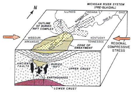
The New Madrid Seismic Zone is made up of reactivated faults that formed when North America began to split or rift apart during the breakup of the supercontinent Rodinia in the Neoproterozoic Era (about 750 million years ago). The rift failed, but remained as a scar or zone of weakness.
During the Mesozoic Era (about 200 million years ago), as the Atlantic Ocean was opening in the east, rifting was once again re-activated and intrusive igneous rocks were emplaced. But again the rifting failed and the continent remained intact, although with a significant zone of weakness. This rift is known as the Reelfoot Rift and coincides with the northernmost portion of the Mississippi embayment. Most of the seismicity is located from 5 to 25 km beneath the Earth's surface.
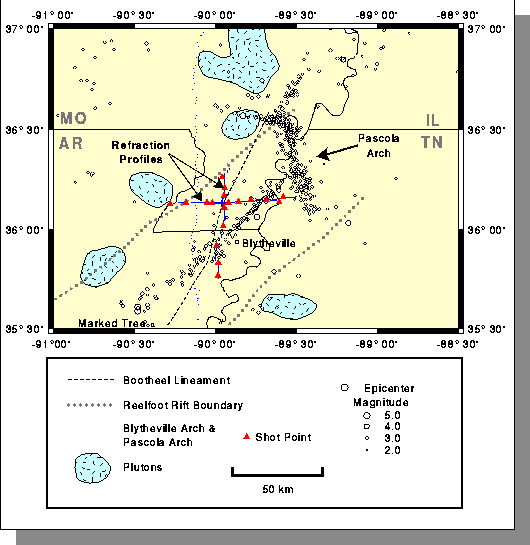
 Two trends are apparent. First is the general NE-SW trend paralleling the trend of the Reelfoot Rift. The second is the intense cross trend, NW-SE, that occurs just southwest of New Madrid. This second trend coincides with an intrusive igneous body which lies deeply buried beneath the sediments of the rift zone.
Several other bodies of deeply buried intrusive rock are known to exist within the seismic zone. The depths of these igneous rock bodies closely corresponds to the depth of the seismic activity.
wikipedia.org/wiki/New_Madrid_Fault_Zone
The focal depth of an earthquake is the depth from the Earth's surface to the region where an earthquake's energy originates (the focus). Earthquakes with focal depths from the surface to about 70 kilometers (43.5 miles) are classified as shallow. Earthquakes with focal depths from 70 to 300 kilometers (43.5 to 186 miles) are classified as intermediate. The focus of deep earthquakes may reach depths of more than 700 kilometers (435 miles).
The focuses of most earthquakes are concentrated in the crust and upper mantle. The depth to the center of the Earth's core is about 6,370 kilometers (3,960 miles), so even the deepest earthquakes originate in relatively shallow parts of the Earth's interior.
-- pubs.usgs.gov/gip/earthq1/earthqkgip.html
good article
livescience.com/forcesofnature/050622_new_madrid.html
vulcan.wr.usgs.gov/LivingWith/VolcanicPast/framework.html
In east / southeast Missouri, the area around Taum Sauk Mountain (Ironton, Farmington) is geologically some of the oldest land in North America, and probably saw volcanic activity. Did you know that granite is cooled magma? (see plutons, top of this page).
Gold in them thar plutons
A mining company has been looking for uranium near Charleston. It's created 4-6 ways in nature, and changes in magma (lava) can cause it. The search was put on hold (May 2009) because the prices dropped.
The New Madrid Seismic Zone (NMSZ) lies directly above an ancient failed rift, the Reelfoot rift. About 550 million years ago, a rift began to form under the present day site of New Madrid [Vogel, 1996]. For unknown reasons, the rift failed and subsequently became filled with sediment. Similarly, 180 million years ago, as the Atlantic Ocean began to open, a rift developed near present day Charleston. This rift was successful. Over the next 180 million years, the margin of continental North America moved thousands of kilometers away from the spreading center, but the crust around Charleston, known as a passive margin, remains faulted [Johnston and Kanter, 1990].
the granite-rhyolite terranes were laid down as a consequence of the impact associated with lunar genesis; widespread rifting of the NA plate occurred as a consequence of the Yellowstone impact circa 1.2 bya, but this was before the NA plate existed as such, still forming a portion of Pangaea at that time.
Failed Basement
The New Madrid Rift Zone predates the Permian by nearly a billion years, dating back to failed basement
A portion of Pangaea consisted of the continental plate we now call North America, which (along with most of the other plates) fragmented following an impact circa 250-252 mya centered at the modern location of Cameroon, Africa. The NA Appalachians were formed from that same impact as an arc segments of an orogenic impact structure that connects with the remaining portions of the Atlas Mountains of NW Africa. It is fairly easy to discern these relationships by consulting www.ngdc.noaa.gov/mgg/image/relief_slides2.html and clicking on the slide labeled 0*E centered on the equator. The Great African Rift system outlines much of this impact structure (not "crater". The Yellowstone impact site appears to have been formed via an impact that completely penetrated the continental crust of Pangaea well before the Cameroon impact created the modern continental plates. The modern mantle location of Iceland correlates with the ancient location of Yellowstone at the time of the original collision circa 1.2 bya.
Plates are not uniform rigid bodies. Moving a tectonic plate is not like pushing a block of wood across the floor, it's more like pushing a rather badly-made jigsaw puzzle across the floor - no wonder if the odd piece pops out of place now and again.
The Mississippi Embayment is the site of a late Precambrian Continental rift that was reactivated in the Mesozoic [e.g. Kane et al., 1981]. The southward plunging trough is filled with sediments that thicken from a thin margin in southern Illinois to about 1000 meters in southwestern Tennessee [Stearns and Marker, 1962] and grade smoothly into the Gulf Coastal Plain [Mooney et al., 1983]. These sediment deposits are unconsolidated and poorly consolidated, age from late Cretaceous to present, and uncomformably overlay Paleozoic carbonate and clastic rocks [Andrews et al., 1985; Braile, 1989]. Other important regional structures include the Illinois basin to the north, the Ozark uplift to the Northwest, and the Nashville dome and Cincinnati arch to the Northeast (Figure 1). The Ozark uplift is composed of Precambrian crystalline rocks and was a site of active faulting in the Devonian [Stewart, 1968; Braile, 1989]. The Illinois basin contains up to 1.5 km of Pennsylvanian age clastic sedimentary rocks and older Paleozoic carbonates. The Cincinnati Arch adjoins the basin on the east, has generally existed since Precambrian time. It is low and broad with several components, including the Nashville Dome.
www.eas.slu.edu/People/AAkinci/receiver.html
The Mississippi's Curious Origins
By Roy B. Van Arsdale and Randel T. Cox
Scientific American Jan 2007
www.sciam.com/
A mountain range once separated the continental interior of the U.S. from the Gulf of Mexico. Some clever geologic sleuthing has revealed how that barrier was breached, allowing the river to reach the Gulf.
Snuggling
On examining a map of the world, many schoolchildren notice that the continents surrounding the Atlantic Ocean can be neatly fit together like pieces of a gigantic jigsaw puzzle. Just snug West Africa up against the East Coast of the U.S. and shove the northern end of South America into the Gulf Coast. That is indeed how these continents were arranged a few hundred million years ago, a fact geologists know, in part, because the plate tectonic movements that created this great landmass left their marks.
Ouachita Mountains
In the eastern U.S., the collision with Africa raised the Appalachian Mountains to heights that probably once rivaled the Rockies. Similarly, the impact of South America created the Ouachita (pronounced "WAH-shi-TAH") Mountains, which run west to east across Oklahoma and Arkansas and formerly blended smoothly into the southern Appalachians. Yet somehow the once continuous Ouachita-Appalachian range was cleaved in two, leaving room for the Mississippi River to flow into the Gulf of Mexico. The explanation for the split, which the two of us have been investigating for most of the past decade, touches on many other mysteries of North American geology, too--such as why you can find diamonds in Arkansas and why the largest earthquake that was ever recorded in the contiguous U.S. occurred not in California or Washington but in Missouri, of all places.
...continued at Scientific American Digital Jan 2007
The Kenner-Segall model suggests that there is a preexisting weak zone beneath the New Madrid fault where stress accumulates over time.
"You may not be able to see very much stress accumulation," observes Segall, "but it's there."
After many years, the stress shifts from the weak zone toward the surface, where it builds up and eventually causes the fault to rupture, triggering a large earthquake as the ground slips some 15 to 30 feet.
How often do these major quakes occur? Every 250 to 4,000 years, say Kenner and Segall, which means that another sequence of large temblors could strike by the middle of the century perhaps sooner.
"The New Madrid fault is like a crack in the wall," comments Segall. "You try to cover it with plaster, but the crack reappears over and over again. It's always going to be there, because it's a preexisting weakness.
-- Stanford Univ.
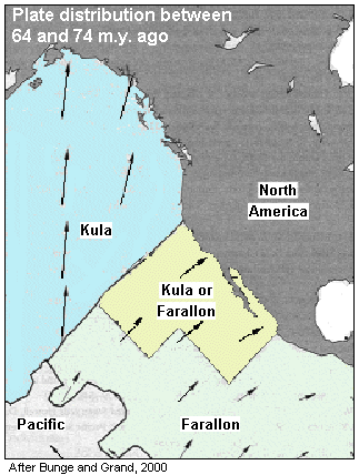 |
Farallon plate
The large Farallon plate made its way toward North America and subducted - pushed under other plates. The Rocky Mountains were created in part of this process. Most of this action affected the western part of the continent, but it even affected the Caribbean. Some scientists (Mar. 2007) suggest its continued rumblings may be responsible for New Madrid action. Click the picture for a general article. |
Powered by Show-Me.net