 |
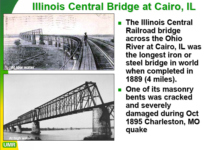
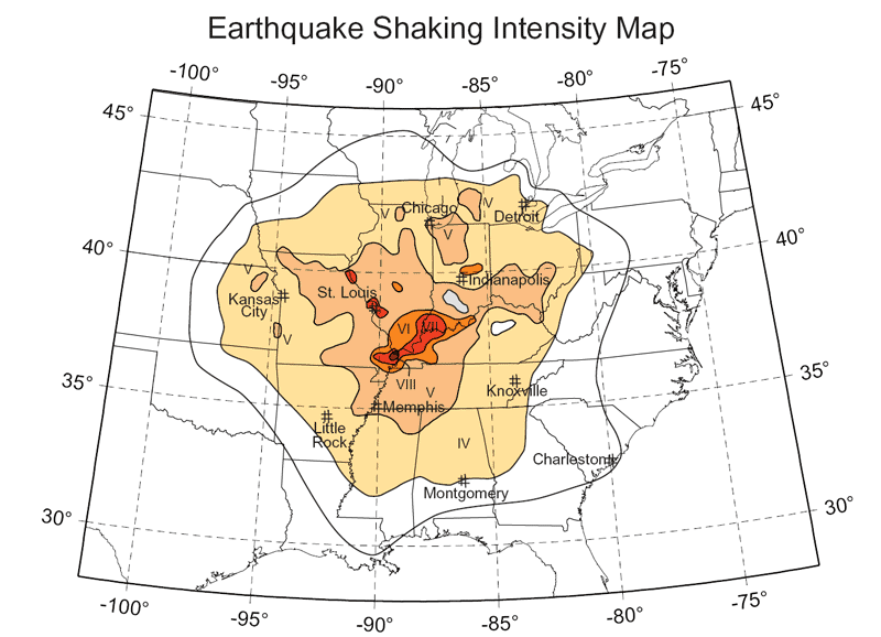
1895 Charleston, MO, EarthquakeOn October 31, 1895, an M6.7 earthquake centered near Charleston, MO, shook a large portion of the central and eastern United States. It was the largest earthquake to occur in the Mississippi Embayment since the New Madrid earthquakes. Structural damage and liquefaction phenomena were reported along a line from Bertrand, MO, in the west to Cairo, IL, in the east. Many sand blows were observed in an area southwest of Charleston and south of Bertrand. Isolated occurrences of sand blows also were reported north and south of Charleston (Stover and Coffman, 1993). Severe damage occurred in Charleston, Puxico, and Taylor, MO; Alton and Cairo, IL; Princeton, IN; and Paducah, KY. The earthquake caused extensive damage to almost all the buildings in the commercial section of Charleston. At Cairo, east of Charleston, most buildings lost chimneys or windows. The courthouse, library, and a church in Cairo, IL, sustained extensive damage, and the brick walls of many buildings in the downtown area were badly damaged. Other damage include a cracked pier on an Illinois Central Railroad bridge over the Ohio River at Paducah and downed chimneys at Gadsden, AL; Evansville and New Waverly, IN; Covington, Spottsville Depot, and Uniontown, KY; St. Louis, MO; and Memphis, TN (Stover and Coffman, 1993). Earthquakes emanating from the central United States tend to transmit seismic energy over much greater distances than similar size shocks in California because the basement rocks are more continuous and dense, allowing them to propagate seismic energy at greater velocities with less damping than crustal units underlying most of the western United States. The Modified Mercalli Intensities for the earthquake are mapped on Figure 3.8. By 1895 there were numerous reports of shaking intensity reported from west of the Mississippi River as compared to the 1811-1812 earthquakes because the region west of the Mississippi River had become more populated. |
|
|
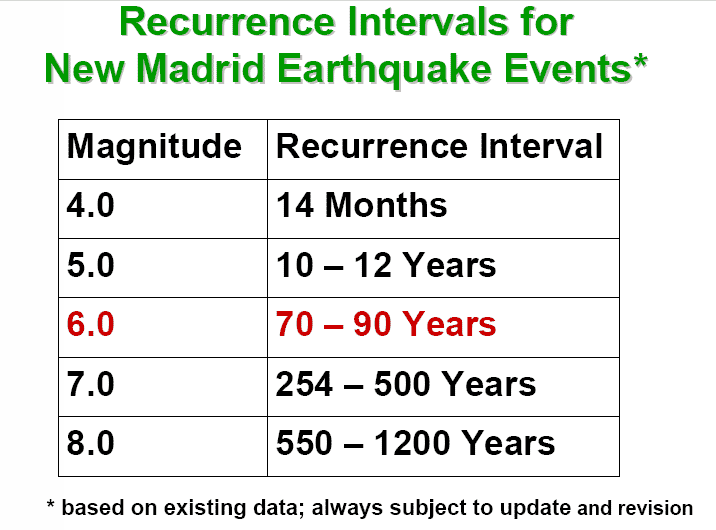
Earthquakes the size of the 1895 Charleston, MO earthquake (Ms 6.8) are believed to have a recurrence interval of 75 years ± 15 years (Hamilton and Johnson, 1990; CUSEC, 1999). This suggests that a similar size earthquake should have occurred sometime between 1950 and 1980. This moderate size earthquake may well be overdue, or the 1895 event may have been a large aftershock in the wake of the 1811-12 earthquake sequence. from http://erp-web.er.usgs.gov/reports/abstract/2003/cu/03hqgr0023.pdf http://earthquake.usgs.gov/regional/states/events/1895_10_31.php
At the Burkett archeological site in southeastern Missouri [near Charleston], there is evidence for at least six earthquakes that induced liquefaction and related ground failures during the past 4,500 yr. The four earliest earthquakes occurred in 2350 B.C. ± 200 yr and may have been part of an earthquake sequence occuring over a period of weeks to months. Sand blows and related sand dikes that formed as a result of these earthquakes served as the foundation on which a Late Archaic and Woodland cultural mound was built. The fifth earthquake occurred in A.D. 300 ± 200 yr towards the end of the Middle Woodland period. The sixth and latest earthquake occurred after A.D. 1670. Given that it produced small sand blows and liquefaction-related ground failures not far from the site, the 1895 Charleston, Missouri, earthquake was more likely the cause of the small historic sand dikes at Burkett than the 1811-1812 New Madrid earthquakes. The 2350 B.C. and A.D. 300 earthquakes are interpreted as 1811-1812-type or New Madrid events. This interpretation is based on the relatively large size of the prehistoric liquefaction features at Burkett, the close timing of the four earthquakes in 2350 B.C., and the likelihood that the 2350 B.C. and A.D. 300 earthquakes also induced liquefaction at other sites in northeastern Arkansas and southeastern Missouri. from http://erp-web.er.usgs.gov/reports/abstract/2001/cu/01hqgr0164.pdf Powered by ShowMe-Net
|