Site Map


Probabilities, magnitude, strength

How much, how soon?

Six millimeters is a quarter of an inch. Experts say if the fault is slipping by four to seven millimeters per year, it's serious. In 200 years, it would amount to more than a yardstick's length. When rock pushes rock that much, something will give.

If it is slipping two millimeters or less per year, experts say the next big shake may be a bit less, delayed another 1,000 years, or even never come. Yet, two millimeters a year x 500 years = 3 feet, rock against rock.

Compare movements of other faults.
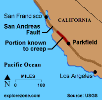
San Andreas fault California's San Andreas fault is said to slip anywhere from 6 to 45 millimeters per year.

Some mid 1990's studies attempted to measured the movement between stations by satellite, and decided it was very little. Permanent sites now record data continuously. One station is attached to a 60' vertical steel I-beam. 2009-10 update: CERI spokesman Gary Patterson says experts are now doubting that measuring movement of the New Madrid fault gives useful information, since it is in the middle of a tectonic plate.


Is the fault dying? Is it just decompressing from the weight of old glaciers?

GPS device at Purdue University detects motion in millimeters.Eric Calais of Purdue University (photo) stands with a global positioning device that measures its location relative to 24 satellites. He says it can detect ground movement of one millimeter per year. Calais says North America is still decompressing from the weight of glaciers.

Accurate measurement of rocks moving a few millimeters a year underneath and across the fault, across Reelfoot Lake, is as difficult as it sounds. Freezing and thawing may be a factor. No one knows for sure if such measurements are meaningful in the middle of a tectonic plate...

Scientists' conclusions vary.


Reelfoot Lake

Reelfoot Lake - Chamber of Commerce

Search "Chief Reelfoot" for an interesting lake legend.
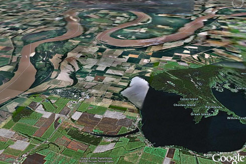
Reelfoot Lake, New Madrid Bend

Reelfoot Lake is in lower right, formed when the area at left end of lake was raised 15-30 feet by an earthquake uplift (animation). Imagine a line running from west end of the lake, across the river loops. Area to SW uplifted, while other sections lowered. New Madrid at top of loop immediately fell 12 feet in 1812. This created both dams and waterfalls on the Mississippi, temporarily. Red=uplift on left map.

Quakes in centuries prior to 1811-12 probably caused some of the uplift and drop. See research by Margaret Guccione and USGS. The lake area has dropped 1.5 to 6 meters (as much as 20 feet). 1811-12 uplifts & drops

The Lake County uplift, as much as 10 meters (30+ feet), can be subdivided into several bulges, including Tiptonville dome, Ridgely Ridge, and the south end of Sikeston Ridge - from USGS.


Prepare for a six

7 - 10%   probability of a repeat of the 1811 - 1812 earthquakes
(magnitude 7.5 - 8.0) - anytime in the next 50 years

25 - 40%   probability of a magnitude 6.0 or larger   (source)


No longer 90%

The probability for magnitude 6 New Madrid earthquakes a few years ago was put above 90% in 50 years. The USGS changed the figures in 2002 to 25-40% for a magnitude 6.0 or greater and 7 - 10% for a catastrophic event in any 50-year period, based on all new science. The chances for a magnitude 6 were decreased, but chances were slightly increased for the catastrophic events. (news release)

Overdue for a 6

A quake below magnitude four is hardly noticed. A six can do serious local damage. A six happens roughly every hundred years in the New Madrid area. A magnitude 6.8 was centered at Charleston, MO (north end of New Madrid Fault) in 1895, which shook the entire Midwest. [That was 110 years ago! ]  PDF report | US shake map.

The fact sheet at http://pubs.usgs.gov/fs/fs-131-02/ has the most current probabilities and scientific justifications.

Cross section New Madrid fault - from SLU, click for more

Metropolitan earthquake damage? In 1811, St. Louis had been incorporated as a town for two years. It had 1,200 people and was built along solid limestone bluffs. The quake cracked a few chimneys there. Its fur-trading founders had wisely chosen not to settle the swampy intersection of the Missouri and Mississippi Rivers, just to the north. Mr. Laclede decided in 1763 where to build his landing (just north of today's landmark arch). 

Memphis was still Indian territory in 1811. The "fourth Chickasaw bluff" would not become a town until 1819, and would not have a newspaper until 1826. 

The table below was recorded by an engineer in Louisville, Ky, of quakes he felt. He rated each into a category of 1st (highest) to 6th (least felt - people felt something, but may not be certain what it was. The term "giddy" feeling was part of description of #6.
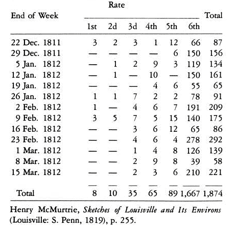
New Madrid 1811-12 quakes per week

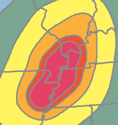
Map of how a big one would shake Kentucky.
Theoretical P-Wave Travel Times from New Madrid

City Travel Time
(min:secs)
St. Louis 0:36
Knoxville 0:56
Wichita 1:32
D.C. 2:27
Duluth 2:28
Philadelphia 2:49
Brownsville 2:58
Golden 3:00
New York 3:03
Miami, 3:10
Ottawa 3:14
Albuquerque 3:16
Boston 3:37
Seattle 5:37
Anchorage 8
Honolulu 10
London 10
Rome 11
Moscow 13
Beijing 13
Guam 14
Nepal 15
Nairobi 15
Brisbane 16

These come from an ANSS estimation.


Richter TNT for Seismic Example
Magnitude Energy Yield (approximate)

1.0 - 30 pounds Large Blast at a Construction Site

2.0 - 1 ton Large Quarry or Mine Blast

4.5 - 5,100 tons Average Tornado (total energy)

6.5 - 5 million tons Northridge, CA Quake, 1994

8.0 - 1 billion tons San Francisco, CA Quake, 1906

8.5 - 5 billion tons Anchorage, AK Quake, 1964

12.0 - 160 trillion tons (Fault Earth in half through center,

OR Earth's daily receipt of solar energy)

160 trillion tons of dynamite is a frightening yield of energy. Consider, however, that the Earth receives that amount in sunlight every day.
http://www.seismo.unr.edu/ftp/pub/louie/class/100/magnitude.html


p-wave P-wave

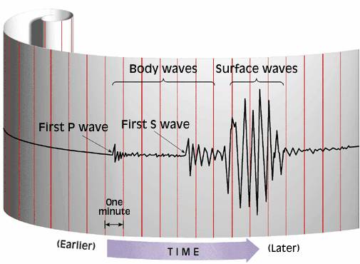
P waves move in a compressional motion like a slinky, while the S waves move in a shear motion perpendicular to the direction the wave is travelling. There are also Love waves and Raleigh waves. P-waves come first, and animals may be more aware of them than humans are. Raleigh waves are the strongest, sometimes called ground roll.

s-waveS-wave

P-waves do not travel beyond 90 km (wikipedia). 

A quick way to determine the distance from a location to the origin of a seismic wave less than 200 km away is to take the difference in arrival time of the P wave and the S wave in seconds and multiply by 8 kilometers per second.
pwave swave quake


China quake waves felt around the globe

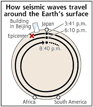
Seismic waves caused by a May 2008 massive earthquake in Sichuan Province, China, twice reverberated around the surface of the Earth, according to the Meteorological Agency's Matsumoto Seismological Observatory.
waves travel around the world

According to the observatory, usually only earthquakes measuring magnitude 8 or higher cause such a phenomenon. However, the latest earthquake, which the agency reported measured magnitude 7.9 on the open-ended Richter scale, was powerful enough to make this happen, the observatory said.

It said waves caused by the earthquake jolted buildings in Beijing, a long way from the epicenter of the temblor.

According to the observatory, the earthquake struck at 3:28 p.m. Japan time Monday. The observatory's seismograph detected seismic waves that lasted for about two minutes at 3:41 p.m., after recording ordinary waves below the Earth's surface.

These long-lasting seismic waves travel between the surface of the Earth and about 100 kilometers deep. The observatory's seismograph recorded these waves again at about 6:10 p.m. and later at about 8:40 p.m. The observatory said the waves reached Japan, traveled to South America and Africa, and returned to Japan again.

www.yomiuri.co.jp


Good graphics from M Tuttle

The New Madrid 1811-12 main shocks were felt over an area covering at least 5,180,000 square kilometers (two million square miles). Chimneys were knocked down in Cincinnati, Ohio, and bricks were reported to have fallen from chimneys in Georgia and South Carolina. The first shock was felt distinctly in Washington, D.C., 700 miles away, and people there were frightened badly. Other points that reported feeling this earthquake included New Orleans, 804 kilometers away; Detroit, 965 kilometers away; and Boston, 1,769 kilometers away.

The New Madrid seismic zone has experienced numerous earthquakes since the 1811-12 series, and at least 35 shocks of intensity V or greater have been recorded in Missouri since 1811. Numerous earthquakes originating outside of the State's boundaries have also affected Missouri. Five of the strongest earthquakes that have affected Missouri since the 1811-12 series are described below.

On January 4, 1843, a severe earthquake in the New Madrid area cracked chimneys and walls at Memphis, Tennessee. One building reportedly collapsed. The earth sank at some places near New Madrid; there was an unverified report that two hunters were drowned during the formation of a lake. The total felt area included at least 1,036,000 square kilometers.


Charleston shakes

The October 31, 1895, earthquake near Charleston, Missouri, probably ranks second in intensity to the 1811-12 series. Every building in the commercial area of Charleston was damaged. Cairo, Illinois, and Memphis, Tennessee, also suffered significant damage. Near Charleston, 4 acres of ground sank and a lake was formed. The shock was felt over all or portions of 23 states and at some places in Canada.

A moderate earthquake on April 9, 1917, in the Ste. Genevieve - St. Mary's area was reportedly felt over a 518,000 square kilometer area from Kansas to Ohio and Wisconsin to Mississippi. In the epicentral area people ran into the street, windows were broken, and plaster cracked. A second shock of lesser intensity was felt in the southern part of the area.

The small railroad town of Rodney, Missouri, experienced a strong earthquake on August 19, 1934. At nearby Charleston, windows were broken, chimneys were overthrown or damaged, and articles were knocked from shelves. Similar effects were observed at Cairo, Mounds and Mound City, Illinois, and at Wickliffe, Kentucky. The area of destructive intensity included more than 596 square kilometers.

above from http://neic.usgs.gov/neis/states/missouri/missouri_history.html

One life, many chimneys

The November 9, 1968, earthquake centered in southern Illinois was the strongest in the central United States since 1895. The magnitude 5.5 shock caused moderate damage to chimneys and walls at Hermann, St. Charles, St. Louis, and Sikeston, Missouri. The felt areas include all or portions of 23 states.

Although the motion during the first shock was violent at New Madrid, Missouri, it was not as heavy and destructive as that caused by two aftershocks about 6 hours later. Only one life was lost in falling buildings at New Madrid, but chimneys were toppled and log cabins were thrown down as far distant as Cincinnati, Ohio; St. Louis, Missouri; and in many places in Kentucky, Missouri, and Tennessee.

10 meter upwarp

The Lake County uplift, about 50 kilometers long and 23 kilometers wide, upwarps the Mississippi River valley as much as 10 meters in parts of southwest Kentucky, southeast Missouri, and northwest Tennessee. The uplift apparently resulted from vertical movement along several, ancient, subsurface structures; most of this uplift has occurred during earthquakes. The Lake County uplift can be subdivided into several topographic bulges, including Tiptonville dome, Ridgely Ridge, and the south end of Sikeston Ridge. A strong correlation exists between modern seismicity and the uplift, indicating that stresses that produced the uplift still exist today.

Tiptonville dome, which is 14 kilometers in width and about 11 kilometers in length, shows the largest upwarping and the highest topographic relief on the uplift. It is bounded on the east by Reelfoot scarp, which has a zone of normal faults (displacement about 3 meters) at its base. Although most of Tiptonville dome formed between 200 and 2,000 years ago, additional uplifting deformed the northwest and southeast parts of the dome during the earthquakes of 1811-1812.

A notable area of subsidence is Reelfoot Lake in Tennessee, just east of Tiptonville dome. Subsidence there ranged from 1.5 to 6 meters, although larger amounts were reported. It may be that the lake was enlarged by compaction, upwarping, and subsidence occurring simultaneously during the New Madrid earthquakes.

Other areas subsided by as much as 5 meters, although 1.5 to 2.5 meters was more common. Lake St. Francis, in eastern Arkansas, which was formed by subsidence, is 64 kilometers long by 1 kilometer wide. Coal and sand were ejected from fissures in the swamp land adjacent to the St. Francis River, and the water level is reported to have risen there by 8 to 9 meters. - from USGS

Dense liquid soil

An engineer in Louisville, Kentucky, counted over 1,850 shocks during [December 1811 - March 1812], including three earthquakes of magnitude greater than 8.3 (Richter magnitude). (See table above on this page.) The shocks from these earthquakes could be easily felt as far away as Detroit, Michigan, and Charleston, South Carolina.

The area between the St. Francois River and Mississippi River south of New Madrid to Marked Tree, Arkansas, showed numerous sand blows. A sand blow is a place where liquefacted alluvial soil has geysered out of the surface. Liquefaction is a phenomenon where the shaking of the ground separates the water from the soil holding it, causing the soil to behave like a dense liquid. The lack of water causes the soil to lose surface cohesion, and sand from these blows accumulates to a depth of up to 5 feet in places.

Liquefaction causes land to lose its load-bearing capacity. Areas uplifted as well as subsided (dropped) along the Mississippi River. For instance, the area around Tiptonville, Tennessee, formed a dome (uplift of several yards). Immediately adjacent to the Tiptonville Dome, an area subsided to form a lake 18 miles long and 5 miles wide. It is now known as Reelfoot Lake and is a tourist and recreation area. Ground failure and landslides were apparent throughout the bluffs (Chickasaw Bluffs) alongside the Mississippi River in Kentucky and Tennessee.

Many fissures were made throughout the region, and one local observer recorded that the earth seemed to be rolling in waves a few feet in height. These swells would burst, leaving wide and long fissures. The damage to the area was so severe that Congress passed, and President James Madison signed into law, the first disaster relief act, giving government lands in other territories to people wanting to move out of the area.

During the past two decades, earthquake data recorded by the New Madrid seismograph network have provided new insight into the seismotectonics of the New Madrid seismic zone (NMSZ). Prior to the establishment of the network, the NMSZ was characterized by the less-than-200-year-duration historical earthquake record.

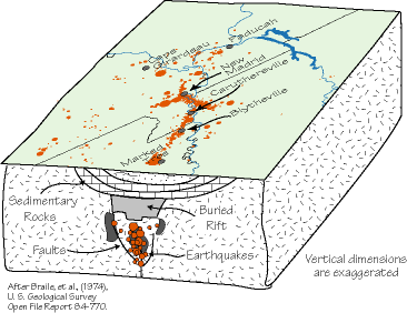
...intraplate seismicity of the NMSZ is associated with an ancient, buried rift that is currently being reactivated by the contemporary, nearly east-west compressional plate-tectonic-generated stresses. Positive gravity anomalies in the upper Mississippi embayment are interpreted to be caused by high density rocks beneath the embayment that were emplaced during the late Pre-Cambrian to early Paleozoic rifting event or during Mesozoic reactivation of the rift.

During the past 150-200 million years, the area has subsided due to the presence of the more dense rocks in the crust resulting in the embayment and the deep burial of the ancient rift structure. Currently, the buried rift has acted as a “zone of weakness” in the stable continental crust and serves to localize earthquake activity within the Midwest.

Recently, new studies of the intensity of shaking of the New Madrid earthquakes has resulted in new estimates of the magnitudes of these events. The revised magnitudes range between M7 to M7.5. Although the estimated magnitudes are smaller than previous estimates, it is clear that these were very significant events as evidenced by the intensity data and their occurrence indicates a significant earthquake hazard for the Central United States.

http://www.eas.purdue.edu/~braile/news/midwest.pdf

Missouri River Valley - 600%

Dr. J. David Rogers, an associate professor of geological engineering at the University of Missouri at Rolla, says Midwestern earthquakes are potentially more powerful than California quakes. According to Rogers, unique geology in the Midwest increases the shaking intensity of earthquakes because seismic energy moves through the dense bedrock at very high speeds, then becomes trapped in soft sediments filling river channels and valleys. Rogers and several graduate students have been modeling synthetic seismic events in the New Madrid region, which produced magnitude 8.0 quakes in 1811 and 1812. Most of their scenarios are modeled after an 1895 earthquake with a magnitude of 6.4 that was centered in Charleston, Mo.

The preliminary results are sobering, says Rogers, who was recently appointed to Missouri's Seismic Safety Commission by Gov. Matt Blunt. Data indicates ground shaking would be magnified about 600 percent within the flood plain of the Missouri River, a development that would cause most of Missouri’s existing long-span bridges to collapse. “You don't even need a really big earthquake to do significant damage in Missouri,” Rogers says. “It could happen tomorrow.”  --from UMR news release Apr 13, 2006

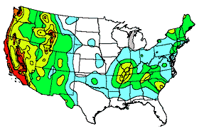
USGS quake hazard map

Every 500 years

New probabilities are based on direct physical evidence of big quake sequences that have been discovered in the last 15 years. Older probabilities were based on using numerical models and extrapolations. USGS and CERI researchers have built a substantial history of events over the last 2000 years. Earlier large quakes may have happened about (BC 2350 USGS) (BC 1100 UALR), (300 AD: MO DNR). Direct physical evidence now shows more recent large quakes occurred around 900 AD, 1450 AD, as well as 1811-12. See the fact sheet (above), study (below). --sciencedirect.com 10/28/2005

Guccione quake dates

One study concludes, "Our best estimate of the average recurrence interval for deformation along the scarp is 400–500 years."
http://www.agu.org/pubs/crossref/1996/95JB01815.shtml
JOURNAL OF GEOPHYSICAL RESEARCH, VOL. 101, NO. B3, PAGES 6151–6170, 1996

Faulting in this area is sometimes referred to as Quaternary. The Quaternary Period is roughly the last two million years.

Holocene refers to the last 10,000 years or so. Those who believe in global warming may be irked to see the Holocene era defined as "a relatively warm period between ice ages".


Richter  Magnitude scale

The magnitude scale most widely used for many years is the Richter magnitude scale, introduced in 1935. Although it is open-ended, the Richter scale does not accurately measure large earthquakes on faults with a great rupture length.

To better quantify the severity of great quakes, scientists have developed the Moment Magnitude scale (M). The moment magnitude measures the total seismic energy released, which is a function of rock rigidity in the fault, the area of rupture on the fault plane, and the amount of slip.

The magnitude scale is logarithmic. An increase of one unit of magnitude (for example, from 4.6 to 5.6) represents a 10-fold increase in wave amplitude on a seismogram or approximately a 30-fold increase in the energy released. A magnitude 6.7 earthquake releases over 900 times (30 times 30) the energy of a 4.7 earthquake - or it takes about 900 magnitude 4.7 earthquakes to equal the energy released in a single 6.7 earthquake! USGS

Seismologists sometimes refer to the strength of an earthquake as moderate (magnitude 5), large (magnitude 6), major (magnitude 7), or great (magnitude 8).

The new Bill Emerson Memorial Mississippi River Bridge at Cape Girardeau is designed to withstand a quake of magnitude 7.5 or greater, and includes continuous seismic monitoring in its towers.

Magnitude=kilowatts -- Mercalli Intensity=signal strength
Charles Richter said, "I like to use the analogy with radio transmissions. It applies in seismology because seismographs, or the receivers, record the waves of elastic disturbance, or radio waves, that are radiated from the earthquake source, or the broadcasting station. Magnitude can be compared to the power output in kilowatts of a broadcasting station. Local intensity on the Mercalli scale is then comparable to the signal strength on a receiver at a given locality; in effect, the quality of the signal. Intensity like signal strength will generally fall off with distance from the source, although it also depends on the local conditions and the pathway from the source to the point.


Mercalli - Intensity scale

In contrast to magnitude, an earthquake's intensity is a highly subjective measure. For many years the Modified Mercalli Intensity (MMI) scale, developed in 1931, has been used to describe the relative strength of ground shaking experienced at a particular location. Seismologists assign intensity using the 12-increment scale that reflects the effects of shaking on people, damage to the built environment,

Modified Mercalli scale Intensity is expressed in Roman numerals of the effects of an earthquake at a particular place on humans, structures and (or) the land itself. The intensity at a point depends not only upon the strength of the earthquake (magnitude) but also upon the distance from the earthquake to the point and the local geology at that point.

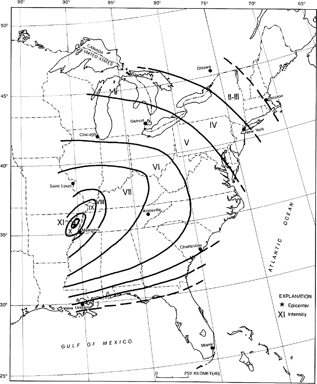
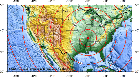
The map below shows energy dissipation (Modified Mercalli scale intensity) through the eastern US from the 1811 New Madrid area quake.

1811 quake energy in eastern US isoseismal mercalli

A clearer version of this map is at http://www.uky.edu/KGS/geologichazards/images/intensitymap1811.gif

http://www.uky.edu/KGS/geologichazards/eqinky.htm    


Learning from History

Geologist-turned-Congressman Samuel Mitchill in 1815 said "[when] five or six witnesses, who seem to have been wholly unknown to each other, agree in so many particulars, [then] their united evidence may be considered as near to the truth as we can expect to arrive."

Mitchill had set out shortly after the New Madrid sequence of 1811-1812 to compile accounts of the earthquakes and develop a satisfactory physical explanation for them. His 1815 publication provides an invaluable compendium of accounts from all over the United States of that time.

http://pasadena.wr.usgs.gov/office/hough/mitchill.html  |  "felt" reports


Jan 1812 quake centered in SE Illinois?

The 23 January 1812 quake did not have a high-intensity "bulls-eye", and could have been centered in southeastern Illinois' White County, near Carmi. A 1968 quake with magnitude 5.3 had a similar broad intensity distribution.

One account, by Yearby Land, described a big crack made in the ground with two feet of vertical displacement. Even in 1858, the feature (38.078 N, 88.118W) could be traced for a reported distance of two miles. Near this crack Land stated that “piles and piles of pure, snow white sand were heaved up’ including some as big as “several wagon loads’. Field reconnaissance verified many of the details in the Land account, and confirmed evidence of sand blows on the surface of the field where they were reported. In addition to providing a clear account of liquefaction, this report appears to describe either surface rupture on an east–west trending fault or substantial ground slumping. None of the earthquakes caused significant damage in the region beyond toppling chimneys, but, in addition to the sparse population, it has been noted that the buildings were all extremely flexible.

see NATURE | VOL 429 | 20 MAY 2004


The first written account of an earthquake in the region was by a French missionary on a voyage down the Mississippi River. He reported feeling a distinct tremor on Christmas Day 1699 while camped near what is now Memphis, Tennessee.

Large fissures opened

On December 16, 1811, shortly after 2 AM, a terrifying roaring noise was created as the earthquake waves swept across the ground. Large fissures suddenly opened and swallowed large quantities of river and marsh water. As the fissures closed again, great volumes of mud and sand were ejected along with the water.

The earthquake generated great waves on the Mississippi River that overwhelmed many boats and washed others high upon the shore. The waves broke off thousands of trees and carried them into the river. High river banks caved in, sand bars gave way, and entire islands disappeared. The violence of the earthquake was manifested by great topographic changes that affected an area of 78,000 to 130,000 square kilometers.

[To convert square km to statute square miles, multiply by 0.386109]

On January 23, 1812, a second major shock, seemingly more violent than the first, occurred. A third great earthquake, perhaps the most severe of the series, struck on February 7, 1812.

Although the death toll from the 1811-12 series of earthquakes has never been tabulated, the loss of life was very slight. It is likely that if at the time of the earthquakes the New Madrid area had been as heavily populated as at present, thousands of persons would have perished.


Sitemap


Powered by Show-Me.net