A Tour through the New Madrid Seismic Zone
The 200th anniversary of the big New Madrid shakes has just passed.- Dec. 2011- Spring 2012. This page includes a bit of geography, earthquake and (a bunch of) general history. It is intended for those driving through the area, who want the short, easy tour. Some information comes from "The Earthquake that Never Went Away" by David Stewart. You may want to print this page and take it with you.
Partial apologies for throwing in several "side trips" - but we think and hope some of them will interest you.
You're driving south on I-55 from Cape Girardeau, ending at Blytheville.
River rerouted
At the south edge of Cape Girardeau, as you pass the Regional Airport, notice the flats you are in, with ranges of small hills running along the north and south. You are in an old shallow Mississippi River bed where, until 10,000 years ago, the river turned west. Look at your map. During the first part of the ice ages, it flowed west past Advance, to the hills near Poplar Bluff, before heading south.
During the latter part of the ice age, the water broke through and flowed through Oran and Bell City locations, on the EASTERN side of Crowley's Ridge. A few hundred thousand years ago, a shallow finger of the Gulf of Mexico (Mississippi embayment) came to this area. But that was when the entire Gulf came up to mid-Arkansas.
The Mingo Swamp, er, Mingo State Park and Wildlife Refuge, near Puxico, is a recreated remnant of how a much larger part of this area (south of Cape Girardeau) once was. The swamp, especially at high river levels, was a major impediment to Civil War troops. Read how the North's Gen. Pope led 10,000 troops slogging across a slight ridge from Benton to New Madrid before spring 1862 thaw, which surprised and scared the South troops into fleeing New Madrid occupation, leaving supper on the stove.
Side trip: Drive down highway 25 through Chaffee and Oran. Note the smooth rock outcroppings from the low hills. Imagine yourself submerged in a shallow ancient (Mississippi) River bed for these several miles. Highway 25 meets 61 at Morley. You can head on to Sikeston on US 61 for food.
Side trip: Bollinger County Natural History Museum at Marble Hill (west of Cape Girardeau) has dinosaur bones found south of town, trapped in an earthquake fault. Also has Civil War memorabilia.
Thebes Gap
Side trip: Thebes Gap (Missouri side of the river), English Hills, Benton Hill, Commerce Lineament. Go visit River Ridge Winery's hospitality, just north of Commerce. Take the Benton exit, go almost to the main part of Benton, and look for Route E, turning right, then east, in a residential area. It's easy to miss.
If traffic permits (it will), and leaves do not obstruct the view, stop on the overpass of I-55 and study the expanse of flat horizon to the south. You can see the curvature of the earth. The Ohio river flowed from left to right at the bottom of the hill.
You'll quickly drop to the bottom of the hill and drive alongside hills to the north and flatland to the south. You are driving on top of the Commerce Lineament, a seismic oddity that runs in a nearly straight line from Indiana to Arkansas. In past eras, it has seen serious quake activity, that churned soils of different eras into a big mixing bowl which is the hill. Scientists hired someone to cut trenches in that hill, and studied the heavily churned cross section of soils. Sonar-type soundings confirm a big crack beneath your road. The same kind of churning has been found at several points along the LIneament - including north of Metropolis IL and near Qulin, south of Poplar Bluff, Mo.
Seismic activity here 10,000 years ago probably helped the river break through the "Thebes gap", which allows the Mississippi to make a sharp EAST bend south of Cape, then to Cairo. Before that, the OHIO River [that's the OHIO river] was flowing where you are driving. It turned south near the Benton exit of I-55, and merged with the nearby Mississippi waters, near Marked Tree, Ar. The Ohio's path across Southern Illinois was just south of State Route 146. Find Karnak and Tamms. Geologists suspect a large New Madrid quake in 900 AD dropped the ground between these towns. It filled back in, but the soil is different than in surrounding areas.
Once you get to the River Ridge winery, you can walk out (3/4 mile) to look down on the river from the top of the gap, though the view is partially obstructed by trees. The village of Commerce has no levee, and has a marker of how Lewis and Clark found the Tywappity Bottoms here. Back at I-55, Diebold Orchard sells fruit, apple cider, pastries, at the Benton exit.
Sgt. John Ordway, best journal-keeper of the Lewis and Clark expedition, returned to the Tywappity Bottom area and New Madrid, where he prospered by quickly owning apple and peach plantations, until the big quakes, which left him destitute.
A 1990 quake, a couple months before the Iben Browning media frenzy, was centered at New Hamburg, a little town just west, and along the Commerce lineament. If you visit it, you can probably eat very homestyle good food in the back of a local grocery. Say hi to the couple who've run it for 40 years. A tavern across the street is regionally famous for good food. A bed and breakfast is at the end of town, with a pretty lake. The town of Kelso, just up the road, has a steak restaurant in an old bank, beside a beautiful Catholic church. Both towns are just north of Benton on US 61.
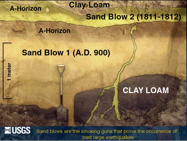
Benton Hill: From the top of the "Benton Hill" of I-55 just north of Benton exit, it seems you can see all the way to New Orleans across the flatland. This is the northern beginning of the New Madrid Seismic Zone (per David Stewart). Note that the road actually dips a bit at the bottom of the hill, then comes back up, at the exit. This dip probably happened during the quakes. An elliptical sand boil of several hundred feet is a bit east. In the last 30 years, paleoseismologists have gotten serious about digging into the sand boils across the NMSZ. They've found shakes dating back to 2000, even 4000 BC and further, even though the river has washed away much of the evidence.
Side trip: You can drive from the east side of the Benton exit, (or south from Commerce) to Charleston, Mo., across flat farmland. An 1895 magnitude 6.7 quake was centered out here, a few miles north of Charleston and opposite Cairo IL and "Dogtooth Bend" of the Illinois side. But... there's nothing noticeably earthquake-related, to see. This quake shook down buildings in Sikeston and messed up the top of the Cairo library, but did not claim any lives. We're overdue for another 6+ quake, which this time would very likely claim some lives. Remember, a 6.7 magnitude is twice as strong as a 6.5. Many scientists now believe the big ones of 1811-12 were high 6's to perhaps high 7's, probably not 8's.
Grab an eye-level view of the river at Commerce. A Lewis & Clark marker tells of friendly Indians near here who wanted to trade for the expedition's dog mascot. River views between here and Cairo are hard to find. In 1800, this side of the river was Spanish territory, with French, British and US forces all gathered nearby, wondering the outcome. Then Napoleon needed money and sold off the Louisiana Territory while Lewis and Clark were wintering opposite St. Louis. If New Madrid hadn't had its shakes, it may have become larger than St. Louis. It was a thriving river port. Before the shakes, legend says drunk riverboat crewmen would enjoy stretching a cable across a street then mowing down anything and anybody in the way.
The multi-story Cairo Custom House Museum, city library across the street, and nearby Magnolia Manor, are well worth a visit for Civil War era buffs. Cairo's dining isn't elegant, but very tasty. At the height of westward expansion, the Custom House housed a huge post office funneling mail to and from the west. Cairo at one time had about 15 pharmacies and still more taverns. There were once dreams of a series of canals through town and drawings that made it look like the parliament buildings of London. But early planners forgot that rivers rise.
During the early part of the Civil War, Union troops at Cairo under supervision of Ulysses Grant built to 20,000 while 19 miles downriver (Columbus-Belmont) Confederates trained an equal number. Grant proved his early war savvy here by (1) "taking Paducah" without ever seeing the enemy (2) performing a small battle at Belmont that improved morale and limited further Confederate activity at Columbus (3) capturing two forts on the Tennessee border south of Paducah which opened up the south and cut supply lines to Columbus.
At the confluence of the nation's two largest rivers, you can camp (Cairo city park) (if the water isn't up) with riverboats passing at eye level on either side. Tie this trip to Wickliffe, Ky., Columbus-Belmont park and the ferry, further down this page, and even Reelfoot Lake.
Between Cairo and Cape Girardeau on the Illinois side ... along Illinois 3 just north of Thebes, is a scenic overview of the river making a 90 degree bend.
 |
Pull off where the large power line crosses, and admire. This is the "Thebes gap" probably made 10,000 years ago by shaking on the Commerce Lineament. Before that, the river did not pass here (see above). Just south is a small tourist walkway to the river. Then take the small side road in to Thebes. See the dual-track rail bridge built in 1905, still handling lots of rail traffic between Dallas and Chicago. Perhaps 35 crossings per day. It was built to handle the new motor cars, as well, but that part was never added. The use of concrete pillars was new and questionable when built, but has stood the test of time and made it to be considered the strongest bridge on the Mississippi. Many runaway barges have struck a bridge pillar over the years with no damage to the sturdy structure.
On the hill overlooking is an old stone courthouse where some say Lincoln tried a case or maybe just visited here, and runaway slave Dred Scott may have spent a night in the basement. Open by appointment only. Call southernmostillinois.com.
A small road runs under the Thebes bridge, and along the river, closed during high water. A clearing a mile south is where archeologists have investigated a settlement 9400 years before present. It's one of the first vestiges of civilization in North America, with "Dalton tools", meaningful to archeologists. The river was shallow in this five mile stretch of Thebes gap. Ancient folks could likely walk across on pitted limestone during low water. Young Mark Twain was a riverboat pilot whose boat was crippled here by hitting rocks, and barely made it to Cairo.
Olive Branch has a good local homestyle restaurant on the highway (row of windows in the front). Just down the road is Horseshoe Lake, an "oxbow" lake probably made by the evolution of the Mississippi River, and known for fishing, camping. Lewis & Clark spent a night at the south end.
---
Side trip: At Mound City (on the Ohio River, a bit east) is a Civil War national military cemetery. Mound City was a staging area for the north to fight the war. Boats were built and repaired on the drydock rails. It could handle 20-25 boats at once. It had a large stationary hospital (where the grain bins are, now) and a floating hospital which cared for and buried troops of blue and grey, black and white. The first Navy nurses were here, local midwives who could deal with seeing blood. More info from Cairo Custom House guides.
---
Side trip: On Rt. 37 a bit north of Mound City, turn east at Grand Chain (may be called New Grand Chain) -- go four miles (Tick Ridge Road is a good blacktop) and follow a sign to the right indicating an Ohio River boat launch. You'll find a broad sweep view of the Ohio River and a restaurant with a few motel rooms to help enjoy the view. grandchainlodge.com - call ahead before you depend on specific accommodations. Historical notes: in the 1700s either here or just downriver on the right was a huge buffalo tanning operation sanctioned by the King of France. Illness and frustration of Native Americans stopped it.
Then just after 1800, as Lewis and Clark were passing by, half the US military was here in a four mile sloping stretch of Cantonment Wilkinsonville where Commander Wilkinson and former vice President Aaron Burr likely conspired to conquer Mexico and/or as much of the future southwest US as they could. Read about the Aaron Burr conspiracy. The British, French, Spanish and Americans were all nearby and wondering about the potential of war, when the Louisiana Purchase solved the problem and President Jefferson disbanded Cantonment Wilkinsonville. Burr and Wilkinson worked together in Benedict Arnold's office several years earlier, where the "traitor" mentality may have been fostered.
There are absolutely NO museums, signs, or visitors centers, about these two parts of history. Click the grand chain lodge link just above, for more. See on your map the way the Ohio makes a half moon arc between Cairo and Paducah. This is at the top of that arc. The view of the river includes almost to Cairo and past Paducah to the mouth of the Tennessee River. The shallow "Grand Chain" of rocks here once allowed squirrels by the hundreds to hop across rocks in the Ohio between the future Illinois and Kentucky.
---
Side trip: The Stars and Stripes Military Museum is just south of Bloomfield, Mo., half an hour west. It and its military cemetery are relatively brand new, well-kept, and the museum is expanding. Bloomfield claims to be the birthplace of the military Stars and Stripes newspaper, published by some bored and perhaps imbibing Union troops during the Civil War. Bloomfield is on part of Crowley's Ridge (running north-south). We have maps of it on this website. You can't read much about New Madrid Fault without reading about Crowley's ridge. Dexter restaurants (five miles south) are famous for their barbecue ribs.
Plutons:
Look at the road map again. Find Bloomfield, and visualize it in the middle of a 25-mile circle. We have several maps on this website of plutons along the New Madrid Seismic Zone. The largest one is the Bloomfield pluton. A pluton is lava that found its way up through the earth's crust because of seismic cracks. The lava type material usually never came completely to the surface, but adds to seismic instability because it weighs down the ground. None of it is visible in this area. See pictures of the Devil's Tower pluton in Wyoming, exposed by erosion, to visualize what we're talking about.
Sikeston: Stop by the depot museum downtown, and eat at the famous Lambert's Throwed Rolls Cafe. The municipal power plant is northwest of town off Salcedo Road. There are sand boils very near, even partially under it. Read a link on this website to author Sam Penny's version of how Sikeston would shake during a 7.9 quake. In spring, see Charleston's beautiful azelas. Big Oak Tree state park has a nice walk on a metal-grated sidewalk through native forest.
Back to I-55, south toward New Madrid. Look for spots of noticeably whiter soil. These may well be sand boils. The interstate seems to dart around some swampy places.
New Madrid observation deck
Exit at New Madrid. Find the museum, on the levee at the end of the main street. Remember that the entire town sank 12 feet during the Feb. 7, 1812 quake, where nearby sections of land rose as much as 30 feet. After having an earthquake burger (top bun split in the middle), find the observation deck on the Mississippi.
The original site of New Madrid is now halfway out into the river. We are standing at the top of the big loop on your map, with river flowing from left to right. This loop was once called Bessie's Bend. A little town of Bessie was in the neck of the bend. Boat travelers would spend the night in the hotel, exiting the boat on the eastern shore. Then they would board the next morning on the western side, less than a mile away, but the boat had gone twenty miles around the bend, saving them some time.
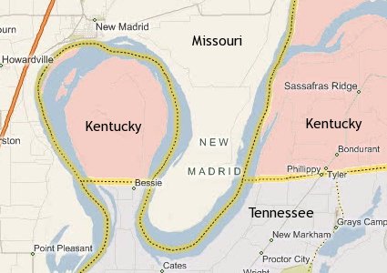
Mark Twain wrote of an interesting feud on Kentucky Bend, or Bessie's Bend. A church was built exactly on the Tennessee-Kentucky line in the middle of that loop. A serious feud between two families continued for years. Members from both families would take their places for Sunday morning worship, one on the Kentucky side of the building, the other on the Tennessee side. When they bowed in prayer, those nearest the isle, with guns, kept their eyes open and watched the other side, for protection. See Wikipedia "Kentucky Bend". If you're visiting on the Tennessee side, the church cemetery, with sign, is just north of where Bessie is noted on map above.
28 boats lost over the falls
Back to the New Madrid observation deck. To the right, six miles down river, are smokestacks from a power plant and aluminum plant. Those smokestacks and the Marston Rest Area of I-55 mark the approximate center of the largest earthquake ever to hit the continental US (Feb. 7, 1812). To the left, the earth to the south and west had pushed up several feet, and caused a waterfall. This diagonal "push" crossed the river's bends THREE times.
Even though the water ran backward for only a few hours, author David Stewart says the falls here lasted for a few days. Flatboats were the norm, almost helpless to quickly maneuver. Stewart says 28 of 30 boats capsized and were swamped, with almost total loss of life. Witnesses from where you are standing could hear frantic screams of the boatmen (a couple miles to the left, SE, but upriver. Another, lesser dam and waterfall were just downstream (to the right), and may not have lasted as long. The second dam was less than a kilometer to the right from where you are standing. See maps on this site showing Reelfoot Fault creating the Reelfoot Lake dam, and jaggedly crossing the top part of the loop.
Also in New Madrid (walking distance): Higgerson School is a one-room school, moved to downtown, with original furniture. Hours may vary. The Hunter-Dawson house is a one-block state park, a magnificent southern mansion a few blocks north of downtown. Museum on levee has several things to see, with nominal admission.
Civil War Side trip: Drive a bit out state route WW, ENE of New Madrid. You'll be on a levee road, seeing a fairly well-drained bayou (low marshy area). At first glance, it's very boring. Visualize crews from several civil war Union gunboats, waiting on the river just east for permission to run the blockade of Island #10 in the south bend of the river loops. While waiting, they cut a canal across this section to bypass the blockade and get supplies to other Union forces. They used huge U-shaped saws mounted on barges to cut the trees 4 and a half feet below the water line. Some of this bayou area is still wooded, as it was then. Read more civil war activity on this website.
From the New Madrid river overlook marker:
...constructing a canal 50 feet wide and 12 miles long, 6 of those miles were cut through heavy timber where every tree had to be sawed off 4 1/2 feet below water. This remarkable feat was accomplished in 19 days.
As the canal was finished, they also ran the blockade and took control of this section of river.
There are elaborate valves in place just out this road to control the drainage of the bayou into the Mississippi. There is an ongoing court battle/public argument on whether this (large) area can be used as Mississippi River overflow during flooding. Local farmers' interests are on one side, versus interests for many miles along the river.
2011 spring-summer / The Ohio and Mississippi Rivers flooded at the same time, threatening levees at Cairo and other places hundreds of miles up and down the Mississippi, Missouri and Ohio Rivers. The Corps of Engineers exercised their option to "blow" a levee opposite Cairo to relieve stress on the levee system. A triangle-shaped piece of land from Cairo to New Madrid was flooded, eroded and covered with sand. Politicians fretted. Roads and bridges were ruined. Since 1929 it was understood that this MIGHT happen. About 100 lower income homes were lost. $85 Million of single year crop damage. Search Birds Point New Madrid Floodway.
2012 - the Birds Point levee (opposite Wickliffe Ky) is being fully restored.
Read from the Enigma paper, done by expert Eugene Schweig and others in 1996.
The Ohio River ice jam broke up at Louisville falls about the time of {the January quake). [Nolte (1854) reports that earthquakes "loosened the ice"], and many boats that began the trip to New Orleans at the falls had reached New Madrid and tied up for the night of 6 February 1812.
At 03:45 on 7 February the main dip-slip event of the entire sequence began. It created one waterfall or rapids and two flow barriers on the Mississippi River's Kentucky bend; an additional falls may have formed on the bend's western limb by deformation in the hanging wall.
The hanging wall rose beneath the river from 12 km to 17 km upstream of New Madrid. This created an uplift that obstructed flow near island #10 [bottom of the first river loop] and a downdrop falls or rapids downstream of the island [the 2:00-3:00 position of the river loop]. This combination was the most severe river disruption; it generated the great upstream wave and retrograde current so graphically described by Speed (1812) and the "patron" (Shatler 1815). Both travelers' flatboats would survive being swept over the downstream falls.
The second intersection of Reelfoot Fault with the river was immediately downstream of the town New Madrid (within 1 km). It uplifted the riverbed by one-to-several meters, accounting for the large wave and retrograde current at New Madrid, independently described by Bryan (1848) and Nolte (1854).
One Sunday in December, 1990, predictions of climatologist Iben Browning of a 50-50 chance of a quake brought a national media frenzy to town. This webmaster was there when CNN was broadcasting live each hour from in front of the museum, saying the "big one" hadn't happened yet. If it had, all would have been in grave danger. We counted 45 news vehicles, neatly parked downtown, with telephone hookups neatly ran. A sheriff's deputy wondered why CBS alone needed five large satellite trucks. But a St. Louis University seismologist told us the seismograph was even calmer than usual during this time.
Back out near Highway 61 in the southwest part of town is a large sand boil - near a service station. On the internet, check how many small quakes have happened just in the last week, around New Madrid. An occasional week may have none, but they will average almost one a day.
Almost anyone who lives in or near New Madrid will tell you they feel some occasional shakes, but regard them like a passing train or a thunderstorm. We find it incredible how the locals will tell you the shakes happen down the road a bit, not really right here. One expert believes the New Madrid Faulting is more than a Billion years old. The continents pushed and pulled twice, stretching the region 600 million years and 200 million years ago, accounting for the double directions of fault lines you see on a NMSZ map. Compare the many maps of the NMSZ on this site to your roadmap to see when you are in the heaviest area of the NMSZ.
David Stewart points out a large sand fissure at mile post 44 under I-55, the railroad and river levee. He says the railroad has a big problem keeping the rails aligned because the daily trains taking coal to the power plant cause mechanical liquefaction. No amount of gravel brought in, seems to help. The sand fissure under I-55 is 1.5 miles north of the Marston rest area. There are several sand boils just south of the two plants.
I-155 Bridge
The bedrock below Pulaski County, Illinois, north of Cairo, is at 28 feet. If you happen to be at the east side of the I-155 Caruthersville-Dyersburg river bridge, note the gentle, peaceful-looking hills. This is the junction of two main segments of the New Madrid Fault. The bedrock is down 28-hundred feet. The bridge pylons are less than a hundred feet deep. River-bottom soil can amplify the effects of a quake, six-fold. On the east side of the bridge, take state route 181/79 north toward Ridgely. After 10 miles, it curves. That's Cottonwood Point. A fault segment that also bears that name, starts here, and continues SW past Blytheville, to Marked Tree, AR.
One theory why the rock is so far down... Seismologist Roy Van Arsdale believes that way, way back, the bottom half of what is now the Mississippi River, passed over a "hot spot" that helped erode the area, leading to the "Mississippi embayment" - a shallow finger of the Gulf of Mexico, that came up to Cairo.
Read elsewhere on this site of a hapless fellow in a river bottom near Buffalo, NY, who thought he was "having a fit" when the shaking originated very near -here-. The bridge's deepest pylons go down less than 100 feet, admittedly anchored on sand. Liquefaction has different forms, and even the beating of helicopter blades can cause it. A State of Missouri bridge engineer in 2006 told us in an email:
Our current information shows that bedrock is located beneath about 2800 feet of sands, gravels, and hard clay strata. Construction of the bridge was completed in 1974. The approach spans are supported on friction pile that were driven to about 50 feet in depth.
The main truss spans are supported deep caissons that bear on dense sands 50 to 90 feet below the river bottom. There was a partially completed seismic retrofit study in 1995 that projected a cost of $32M. (The upgrade was not done because of cost.)
Little Prairie
Find the big grain elevator on the river at Caruthersville. The town of Little Prairie was halfway across the river in front of it. The grain elevator is 10 stories tall, and is a landmark for several miles around. Little Prairie flooded without warning during the first quake, in mid-December. Stewart says,
Crevasses were everywhere. Sometimes cracks would open and then slap shut, spouting groundwater over the tops of tall trees. Sometimes the ground would part beneath a large tree, splitting the trunk from the bottom up. Then about noon another great shock hit the town, and the ground began to liquefy and the town began to sink. Some 100 people gathered their belongings and children on shoulders and walked eight miles through cold, waist-deep waters, never knowing when they might trip over a buried stump or fall into an unseen crevasse. They reached higher ground near Hayti.
Jan. 23rd quake wipes Point Pleasant
The epicenter of the January 23rd quake is listed as east of Portageville. It wiped away the town of Point Pleasant, not far south of Marston. The people there had already fled. Point Pleasant is still on the map, but a mile west of where it once was. The epicenter of this one is less clear than of the others. Some say it may have been near Carmi in southern Illinois, where a two mile crack was found with two-foot vertical displacement, and wagonloads of pure white sand piled on the surface. Point Pleasant also had Civil War activity.
The Beach
Between Hayti and Kennett is a 136-acre sandboil, once known as "the beach". It's near Deering. Some of the sand has now been removed, making it suitable for rice production.
Big Lake, west of Blytheville, was formed in 1811-12. It handles overflow storm water from the entire Bootheel. See five parallel ditches east of Kennett draining into Big Lake. The Bootheel drained pretty well before then 1811-12 quakes. Then millions of dollars of drainage work in the early 20th century again made many acres of farmland valuable. Also see the Diversion Channel, a large ditch between Cape Girardeau and Scott City, draining into the Mississippi. The Little River Drainage District, headquartered in a small office in Cape Girardeau, is probably the largest such district in the US. It keeps ditches clean and taxes landowners.
Chickasaw Bluffs - eastern side of the Mississippi River
Bluffs line most of the river between Hickman, Ky., and Memphis. See Wikipedia for location of the four bluffs. Memphis is on the "fourth Chickasaw Bluff". Chickasaws did not hand over their land until after the 1811-12 quakes. The quakes caused landslides at various places. Once a landslide starts, the spot is never completely "healed" from further potential damage.
Just south of Wickliffe, Ky (opposite Cairo, IL) is a landslide bluff overlooking the river. It's where George Rogers Clark built Fort Jefferson, to watch over the new territory he had claimed for the Commonwealth of Virginia, and its governor, Thomas Jefferson. His brother William Clark (Lewis & Clark) stopped by to check on the abandoned site as they passed Cairo in 1803, a decade before the big shakes. Clark later was territorial Governor, and made the first-ever application for federal aid for New Madrid quake victims. Columbus, Ky, has had serious bluff landslide problems which threaten homes. The government recently stepped in and managed to slow the process.
Columbus Belmont Park
Control of the Mississippi River was strategic to winning the Civil War, in the early 1860s. Confederate forces thought they were entrenched high on a very scenic bluff overlooking the river at Columbus, Ky. They tried to block the river with a huge chain, which broke and sank under its own weight. The "rebs" also had a camp at Belmont, Missouri, on flatland just across the river. General Grant was stationed at Cairo, IL, brought some troops, skirmished then burned the Belmont camp. The following spring he took control of two forts south of Paducah. The "rebs" up on the hill, feared their supply lines were cut, and promptly cut and ran. No further shots were fired to conquer Columbus. The park is a beautiful place to visit, or camp for a few days. It has literal trenches the troops used, and a restored old home - museum that was used as a hospital.
Also, read on the internet about the battle of Island 10, at the bottom of the New Madrid loop. (Links and pics are on this site.) The "Yanks" did some daring moves, sneaking metal gunboats past island 10 (a big sandbar) in the middle of the night, during a thunderstorm, to help open the river. The North also pulled heavy equipment four days through a swamp north of New Madrid to surprise and scare the Confederates out of New Madrid, then pulled squeaky canons along the west bank of the Mississippi near Point Pleasant during a night thunderstorm to hide their movements and be ready for capture of Island 10.
Hickman Dorena Ferry
Operates across the Mississippi between a remote area near East Prairie MO, and Hickman, Ky. Your wait is likely less than half an hour. $14 per car. See the "Big Oak Tree State Park", nearby on the Missouri side. Check to be sure the ferry is operating. Visit the "tour de corn" in June, and bring your bike. An East Prairie restaurant installed a train whistle on its roof for nostalgia after the train tracks left. They'll sound it for you. The Towosahgy State Historic Site is on county road 502 SSE of East Prairie, Indian mounds of 1000 years ago. Ask the Big Oak Tree park folks for more info. Lilbourn Fortified Village, just west of Interstate 55 at Exit #44, (the lower New Madrid exit) is another large mound.
Gold in them thar plutons
A uranium mining company has been looking for uranium near Charleston. Uranium is created 4-6 ways in nature, and changes in magma (lava) can cause it. However, the search was put on hold (May 09) because the prices dropped.
Big quakes were on three days
The 1811-12 sequence had a few thousand smaller quakes over 4-6 months. The largest ones were on three days, one in December, one in January and one in February. The December day had three big quakes each a few hours apart. Some researchers count one or two of those as aftershocks, which is why you may get confused reading how many "big" ones there were.
Earthquake lightning
A form of earthquake lightning is seen around strong earthquakes. Look up "earthquake lights" on Wikipedia. Experts have five theories on what causes it. Traveler William Leigh Pierce on the Mississippi, two weeks before the first New Madrid big quake, said, "one half hour before sun-rise, two vast electrical columns shot up from the eastern horizon, until their heads reached the zenith." Such lights were seen in Savannah, Georgia, at the same time those folks felt the first NM quake.
Look at a US map. Near Owensboro, Ky., west of Louisville, the first steamboat was docked for the night when the first NM jolt felt like the boat suddenly grounded. That was 215 miles from the epicenter. At Knoxville and Savannah, it rattled the china, even felt like being on a boat in rough seas. In the Mississippi valley, people said the soil rose and fell in 2-3 foot waves, behaving exactly like ocean waves. Few settlers were in the New Madrid region yet, and virtually none, further west of the Mississippi. Read eyewitness accounts.
We'd love to give you links to everything mentioned above... but this page would turn into one massive page of links.
Tourism links
www.visitsemo.com
www.visitsikeston-miner.com
www.throwedrolls.com
www.bootrpc.com/Tourism.htm (Bootheel tourism contacts by county)
www.charlestonmo.org
eastprairiemo.net
www.dorena-hickmanferryboat.com
www.parks.ky.gov/findparks/recparks/cb
www.dexterchamber.com
shawneeheartland.com
www.southernmostillinoishistory.net
www.caruthersvillecity.com
www.reelfoottourism.com
www.new-madrid.mo.us
www.visitmo.com
starsandstripesmuseumlibrary.org
www.westkentucky.com
www.ozarkvacation.com/nearkansas
www.tnvacation.com/vendors/northwest_tennessee_tourism_council
Thebes rail bridge